Carretera Austral

From Puerto Chacabuco the road is sealed to Coyhaique. I found the traffic light and the scenery fabulous. I camped at a CONAF (National Park and Forestry Department) camp ground about mid way between the port and Coyhaique. Camping in CONAF campgrounds can be expensive for one person, but as it was one of the few times a ranger called to pick up camping fees in my time in Chile I can hardly complain. Unfortunately, a shrine to some saint or other was just across the road and every passing driver in the night felt it necessary to honk for Jesus. The location, however, in a lush valley floor hemmed in by dark and sheer canyon walls was gorgeous (picture taken nearby). The ride next day to Coyhaique involved a long climb and some too-long unlit tunnels. Coyhaique itself was one of my favourite towns in Chile - it had a very laid back and welcoming demeanour, though I was constantly disoriented by its pentagonal Plaza de Armas.
Chacabuco to Coyhaique

Near Coihaique South of Coyhaique, the road continued paved for another 40 or so rolling kilometres into the mountains and the Reserva Nacional Cerro Castillo. There is a nice CONAF campground in the Reserva at Laguna Changuay in a beautiful Lenga (Southern Beech) forest. Other than small birds no wildlife is to be seen, though signs in the campground would have me believe condors and vicunas are around. Extensive roadworks made it appear that road sealing would continue as far as Puerto Ibanez - point of ferry departures to Chile Chico. I have since read that this has happened although the most recent map I've seen (2003 Turistel) still shows the last 42km unsealed.

After a long descent I continued past the Puerto Ibanez turnoff, intent on following the Carretera south to Cochrane. Picture - the Rio Ibanez flows beneath the Cerro Campana (picture shot looking North). The road beyond Coyhaique is rarely flat, though the climbs aren't all that long. For the most part I found the road condition to be very good for a dirt road - especially one subjected to the amount of rain that this road is. Corrugations weren't that common and light traffic meant I could pick my own line without much worry of being run down. The gradient are steep however! Fit the lowest gears you can. Loose and/or stony surfaces were sometimes encountered but rarely for long. Lakes and rivers are filled with water of unreal colours - finely ground glacial particulates suspended in the water see to that. Between the villages of Villa Cerro Castillo and Puerto Murta the road passes an area that was buried by volcanic ash in the 1991 eruption of Volcan Hudson. It makes for a great fast riding, self-draining, mud free road surface and a sometimes surreal landscape. Cerro Castillo

Lago Carrera near Puerto Murta Pictured - Farmland near Puerto Rio Tranquilo on Lago General Carrera. Wooden wheeled wagons, oxen drawn plows and Huasos (Chilean cowboys) are still found in this region. The lake is filled from glacial streams and has coloured water that film just can't do justice to. Lago Carrera is one of the largest lakes in South America at around 120km long and up to 20km wide and covering over 2000 square kilometres. At the border with Argentina its name changes to Lago Buenos Aires. The Chilean side of the border is much wetter, lusher, and more mountainous than the arid Argentine side. Both sides are windy, but on the Argentine side there is one hell of a lot less cover from the wind which is almost without fail blowing from the West.

Pictured - water surges through the short channel linking Lago Carrera to Lago Bertrand. Hanging glaciers are a feature of the Carretera Austral. Cyclists hellbent on getting to or from Tierra del Fuego frequently miss this scenery by catching the ferry from Puerto Ibanez to Chile Chico (or vice versa). Walter Sienko's book "Latin America by bike" suggests taking the ferry because "Otherwise you face a rough, 230-kilometer circumnavigation around Lago Carrera." I suggest he replaces the word 'rough' with 'stunning'.... If rough roads bother you then you wouldn't have made it this far anyway. Oh, and it's closer to 300km too.
Lago Bertrand

Rio Baker
Heading south from the lake towards Cochrane the scenery becomes increasingly arid. Pictured is the Rio Baker about 20km from Cochrane. Cresting a dusty blind rise on the road near here I encountered the two meanest looking Huasos imaginable. They wore greasy woolen Ponchos, had leathery sun darkened skin and took turns swigging from a flagon as they rode. Having finished the booze, the bottle was dismissively hurled to the roadside. Found myself whistling the theme to The Good, The Bad and The Ugly for days. Cochrane has a fabulous general store that sells everything from baby food to tractor tyres. A few kilometres outside town is a lovely National Park (with camping) where I spent an interesting day walking and unsuccessfully fishing with Secret Agent Edgar - an exceedingly talkative man who would tell anyone who's ear he could bend for a few days that he worked for the CIA. Problem was, he talked A LOT to A LOT of people in a lot of languages. But fear not Edgar, your secret is safe with me.

The Carretera continues South for another few hundred kilometres to Villa O'higgins although Cochrane marked the 3 month point of my journey - the point at which I'd decided to turn North.

It took a day and a half to retrace my steps to Lago Carrera where I turned right and took the road towards Chile Chico. I felt this was the hardest stretch of the road around the lake. Even with a tailwind and the huge gear range I had at my disposal, the going was very slow. The road surface was often powdery and the gradients very steep. Scenery always scored top marks though. Traffic amounted to a handful of vehicles a day - way more than could cope with the number of Israeli hitch hikers, who traipsed along in well regimented gaggles. When asked why there were so many of them the answer was that they'd just completed their compulsory military training and wanted to get as far away from Israel as they could. How odd then that they should all get away together, dressed in army gear, and wind up marching for days through arid terrain.
Laguna Negra

I started the last 60 kilometres to Chile Chico at 8.00am, yet didn't arrive till nearly 6.00pm. The road constantly climbed (big, steep climbs) and fell just as steeply that I didn't dare let any sort of speed build on the descents, the surface was the worst I'd found. I've read elsewhere that the road has now been paved with concrete for the relatively flat last 10 or 20km to Chile Chico (presumably for access to the large mine I passed). Can anyone confirm this?

Picture below is a composite panorama taken about half way along the Southern shore of Lago Carrera.

Lago Carrera

Looking back into Argentina
The Border crossing involved a long stretch of no-mans-land on a bumpy road of river pebbles. I had the feeling this may have been deliberate, though whack in the middle was a brand new bridge to span the river itself. Los Antiguos on the Argentine side was welcoming. It had a nice grassy lakeside campground - and I discovered quickly that Argentine campgrounds charge by the person, not by the site. In Chile it was usually cheaper for a lone traveller to stay indoors than to stay at a commercial campground (where they charge for a site that can take a whole family - and often won't give a discount for a single person). Food however was pricier in Argentina because the peso was pegged to the US Dollar. Still, by buying food in supermarkets and mostly camping (often wild camping), I managed to stay on budget in Argentina.

From Los Antiguos to Perito Moreno the road is smooth and paved. A rocketship tailwind and flatish road meant I barely had to pedal. At the East end of the lake huge breakers rolled and crashed on the shore. Roadkill suggested I might finally see some wildlife. Perito Moreno is a dusty place that seems to have seen better days. The infamous (amongst cyclists) Route 40 continues unpaved from Perito Moreno to Tierra del Fuego in the South. Don't bank on hitching if the going gets too rough on this road. I met one Dutch couple in Villarrica who thought they'd do just that. Of the few vehicles that passed, none had space for them. They ended up slowly cycling the whole distance, but the wind finally beat them on the final westward stretch between Perito Merino and Chile Chico, so they turned back to PM and caught a bus North (in a round-about manner) to the Lakes district, thus missing the Carretera Austral in its entirety. Bummer.

I cycled on dirt roads around the North shore of the lake over two long days (the wind!) to get back into Chile near Puerto Ibanez. I saw a great deal of wildlife in those days - Armadillos scampered across the track in front of me. Ñandu raced along near the road and I saw plenty of Guanaco too.

From the Argentine border checkpoint the road climbs steeply up a ridge and back into Chile. Picture is from the top of the ridge looking back into Argentina.

There is quite a distance between the Argentine and Chilean checkpoints at this border crossing and the mighty wind and steep climb conspired to stop me from bridging the gap before nightfall - it had taken almost 3 hours to cover just 10km beyond the Argentine checkpoint - so I just camped by the roadside in a farmers field. A good move as it turned out - as I scouted for a place to camp a large bird shadow flashed across my path. I looked up to see a young Condor wheeling around. Overnight the wind died and I was able to enjoy the twisting road and the distant vista of Cerro Campana/Castillo (picture) in my morning ride to Puerto Ibanez. Chilean customs weren't at all phased by my overnight sojourn.
Looking towards Puerto Ibanez

Parque Nacional Queulat

Parque Nacional Queulat

Parque Nacional Queulat
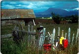
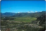
From Ibanez I backtracked to Coyhaique where I holed up in a pleasant Hospedaje with a Belgian hiker and pair of Swiss tandemists waiting on spares for their bike to arrive. Fierce bad weather kept me there for a few days. On the first break in the clouds I scampered down the sealed road as far as the CONAF campground half way to Chacabuco. There I set my tent in a covered picnic shelter and stayed put until the following afternoon to sit out more torrential rain. On leaving camp and heading for the Carretera turnoff a few kms West I met a pair of Dutch cyclists who told me the road North was deplorable - the worst they'd ever cycled. I'd heard this before - one Belgian couple had said I'd have to hitch through the Parque Queulat as they had - it was impossible to ride - covered in stones the size of your fist, they said.

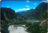
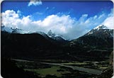
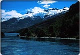
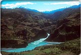
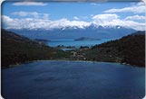
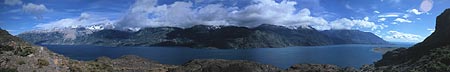
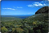
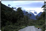
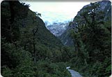
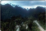
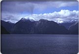
With trepidation I turned onto the dirt road and chugged North. The first few kilometres were good, very good. Because of the dampness the surface was firm, not dusty. Soon, I thought, it would deteriorate. At the end of the day I'd made good time, met about 6 more cyclists and found a comfortable dry bed for the night. Road speed was only slightly slower than sealed road. I believe the first 50km of this stretch - to 15 or so km north of Manihuales is now (2004) sealed. The scenery was lush (3 pics in Parque Nacional Queulat). And so it went for day after day. The constant tailwind helped, but to this day I can't imagine what it was that so many cyclists found so difficult. On the whole the road was in exceptional repair, the scenery was brilliant - even more so when the clouds broke, accommodation was cheap, welcoming and comfortable (so much so that I got lazy about using my tent) and motor traffic was minimal. The "impassable" road in Parque Queulat turned out to be a 200 metre stretch of chunky rubble around a newly built bridge. I got off and walked it.

Sometimes the dense rain forest almost manages to choke the Carretera. Low cloud frequently obscures the scenery, so try to give yourself enough time - I met some cyclists who covered the distance from Chaiten to Coyhaique in five days without seeing a thing. Fortunately I had the luxury of being able to sit out the worst of the weather.

My diary is full of superlatives for this road. Honestly it is cycletouring heaven. Every day going North I'd meet plenty of other touring cyclists - up to ten in a day, never less than two. When I was heading South I met far fewer as the general flow seemed to be North to South and as I was moving with the flow we tended to not see each other. The majority seemed to be heading to Tierra del Fuego and a surprising number were doing end-to-end rides of either South America or all the Americas. Too many of them, I thought, were skipping the circumnavigation of the Lago Carrera in their haste. Still, if you're going to be in a rush to get somewhere you may as well be hastening slowly on a bike.

At Villa Santa Lucia, about 80km South of Chaiten I veered East to Futaleufu and Argentina. Pictured is the forboding Lago Yelcho on the Futaleufu road. In a guest house at the end of this day I was served up trout for dinner - trout caught in the stream in the back yard. Oh, and the homemade bread at breakfast....mmmmmmm.
A stave church near Villa Santa Lucia
Lago Yelcho


All text and images copyright Syd Winer 2004
Feedback